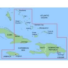
MapSource BlueChart is Garmin's exclusive marine cartography and was developed to provide you with mapping flexibility and options you've never had before. This line of cartography products is designed to provide interactive viewing of detailed nautical chart data, thereby providing navigators with innovative object-oriented cartography. These detailed electronic nautical charts look just like paper charts when displayed on your Garmin chartplotter. Features include shading between depth contours, spot soundings, navaids, port plans, wrecks, obstructions, inter-tidal zones, and more. BlueChart offers much larger coverage areas for half the price. MapSource BlueChart Southern Bahamas provides detailed coverage from Eleuthera Island, Bahamas to the Dominican Republic, including the Bahamian islands of Great Exuma, Great Inagua, Mayaguana, and many others. It also includes detailed coverage of the Jamaican, Haitian, and Dominican coasts in their entirety, the easternmost quarter of Cuba, and the Turks and Caicos Islands, featuring data from explorer charts for the Bahamas. « less
Product Specifications –
Universal Product Identifiers
Brand : GarminGTIN : 00753759040093Part Numbers : 010-C0043-00, Southern Bahamas